Gridded residential population
Explore modeled residential population and the people living near selected infrastructure.
Global geographic overview
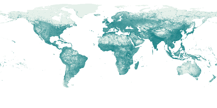
Light to dark green: increasing people; logarithmic display, with high values capped for colour only. Select a point to inspect its retained grid value.
This global overview is independent of the country table filters below.
Source population counts redistributed into 0.5° display cells with GDAL sum resampling; overview only, not the raster used for proximity estimates.
Canada: 1 retained records. The table below shows the first 100.
Mapped sites use publisher coordinates. Records without site coordinates use a country label point when available; those points are not facility or event locations. Multiple records can share a point.
Select a mapped point to inspect its name and source.
| Name / document | 2020 population · estimate | Available display cells | Reference year | Source |
|---|---|---|---|---|
| Residential population · 2020 | 36,666,789.6546 | 5,769 | 2,020 | Original record |
Download country records (JSON) · Download complete explorer records (compressed CSV) · Coverage and definitions
Explore covered commodity suppliers and trade for this country →
Coverage and interpretation
European Commission Joint Research Centre, GHS-POP R2023A, CC BY 4.0. Source 1 km World Mollweide raster estimates residential population from census and built-up data. Uses 2020 estimates, not 2025/2030 projections. Overview sums source counts to 0.5° cells; country context assigns displayed cell centres to generalized boundaries and is not an official national total. Infrastructure estimates use original raster cells within the selected geodesic radius; nearby residence is not an affected-person count.
JSON downloads contain retained records for the selected country, including records outside the current filters. Complete-explorer CSV downloads contain all covered countries. New source snapshots are checked and reviewed separately before publication.
Source: Source attributions and adaptation details below. Source period: GHS-POP R2023A; 2020 population estimate. World Signal Monitor adapted the selection, navigation and maps; no publisher endorsement is implied. File checksums · Source URLs, retrieval dates and hashes